According to the initial plan I had back at home, I should
have walked 105 km already. That's not how it went. The slow start is
frustrating (especially because of the lost day) but without it, I wouldn't have been able
to meet some incredible people.
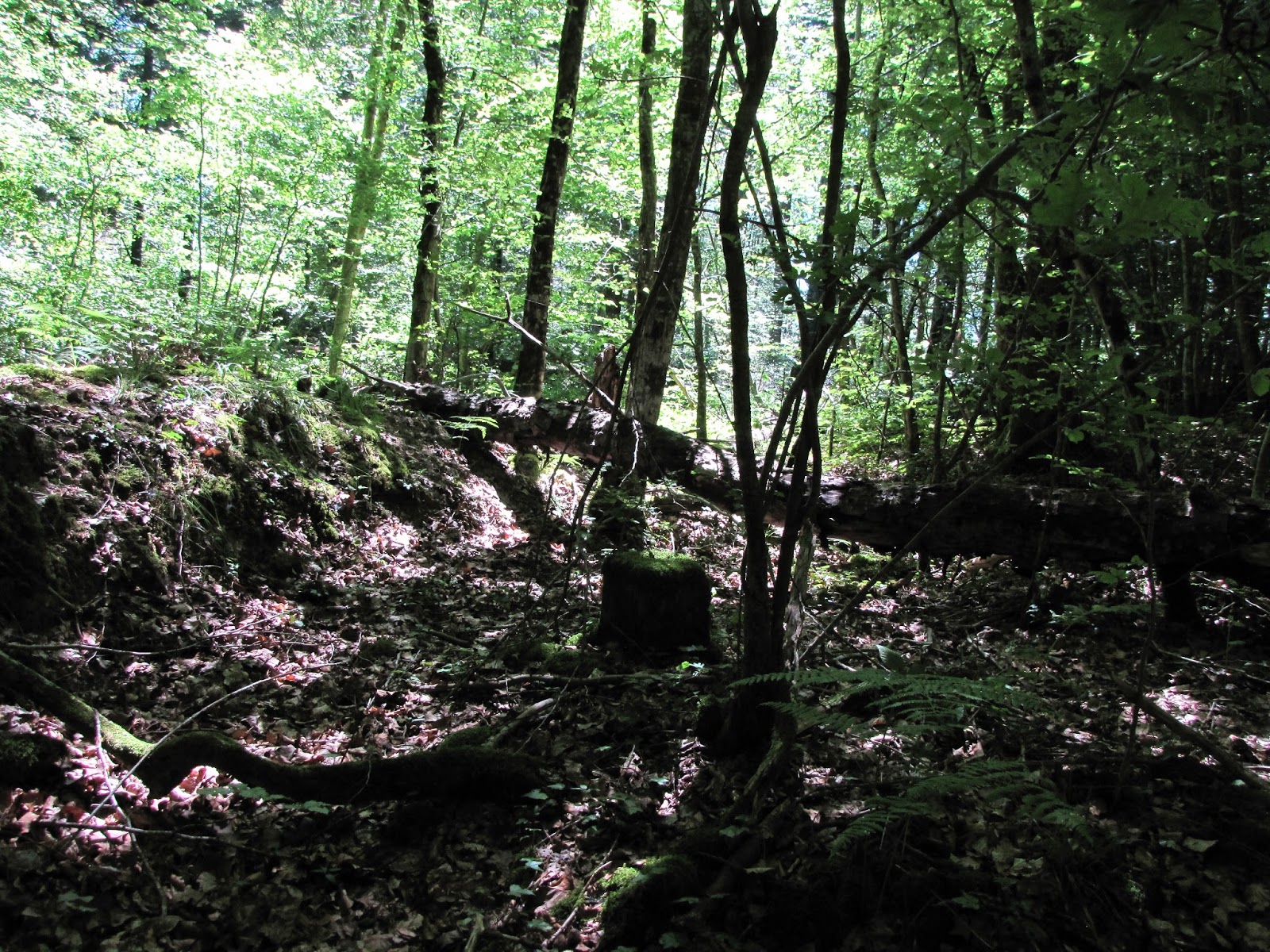
I spend the night at the fish pond again. Sleeping next to
the cows and jumping fishes was a pleasure. Animals in the forest right next to
me weren't sleeping for quite some time too. It was very nice to feel so much
life around me (even though based on the cries I head coming from the forest, somebodies life just ended so the others would continue...).
Day started with no water and a big thirst. I finished half
of the chicken can I started yesterday before sleep, packed everything and
walked to a house to ask for some water (this was one sentence I asked my
sister to write me in French). After that - back to the Zero kilometre
circuit. The railway bridge - a small deja
vu. But this time I took a while to have a good look and to feel the place itself.
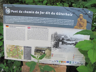 |
| Railway bridge known as the Guterholz. Beneath this bridge the French installed, as with the
previous bridge, a German railway carriage which served as
a command post referred to as Station Post-Wagon. From
the bridge, you can see the old border train station of Pfetterhouse
(1910-1970) which was occupied by the French 55th Territorial
Infantry Regiment on 15 October 1914. The station initially
served as an outpost, but when the front was pushed up to the Largue
river it housed an infirmery and other amenities. A vast semi-concrete
underground shelter was built beneath its walls in 1918. |
It seemed that the
bridge itself was in very good condition, eventhough it didn't manage to escape some vandalism.
The description said that "the old
border train station of Pfetterhouse" was still visible from the bridge;
however, either my eyes were bad or I failed to figure out the exact place that
was hiding behind "from the bridge" expression.
Even though the vegetation narrowed the rail passage under the
bridge, it was still clearly visible
 |
| The path under the bridge was clear and with some modern means of transportation left behind ("They shoot down the horses, don't they?"). |
 |
| Have no idea what this is for. Logical reasoning suggest that it might have something to do with wagons |
.
After passing through the bridge, a path framed with
concreted posts appeared.


I don't know if they were put here originally or later
brought from different places (small probability). I wasn't able to find any
information about this bridge on internet, so I guess that the stones might
have served as "protection fence" (this is a wild guess. I don't know
anything about trains so this guess might be very wrong). The rail-road, which ran under the bridge, at that
time was an international railway running from Bonfol to Pfetterhouse (some of
the remains would be later down the trail). The Franco-Prussian War resulted
that in 1871 Pfetterhouse (Pfetterhausen) was a part of, then, newly formed
German Empire. The border between France, German Empire and Switzerland
situated between Rechesy, Pfetterhausen and Beurnevesin respectively, however,
the front line settled East of the borders (my guess, it was due to the French
offensive of August 7, 1914 on this sector). I think it safe to assume that
this bridge and the tracks was a part of the international Bonfol -
Pfetterhausen line ("train Largue") that was inaugurated in October
27, 1910 and ran since 1970. (The first section of this line that ran from
Pfetterhausen to Dannemarie was opened in September 29, 1910).
While walking further down the path towards point 15, it's
clearly visible the higher ground (the former railway?).
My initial thinking was that the road I walked on was lowered
and the railway that was passing on the side (based on the stone posts) was
left as it was. Or it might be that the railway was initially placed on higher ground (as it often is the case). I don't remember what happened to the railway under the
bridge... It seemed that the railway "disappeared" going deeper into the
forest as I don't recall it. So maybe the current road was built on it..?
The notion that the current gravel road some time ago was some
kind of way (most probably railway, since there was a wagon under the first
bridge) was straighten when I found point 15 - another railway bridge that is
right above the gravel road.
 |
| Former railway bridge known as the Altmuhlenweg. The bridge known as the Altmuhlenweg (old mill path), destroyed by the Germans on 19 November 1944, had remained intact through the Great War. The French installed a German postal railway carriage under the bridge. It was equipped with a telephone and served as a command post known as Post-Wagon-Largin. The weakness of the protection against shells was compensated for by the relative comfort offered by the railway carriage. |
This bridge, however, is in much worse state than the former
one (it's no wonder, known that it was destroyed).
 |
| One of the sides of the bridge. It was heavily covered with vegetation so it's hard to see the remains themselves. The red line indicates my stick size (for the purpose of better understanding of the scale. The size of the stick is about 110 cm (43.31 in)). You should imagine that almost all of this vegetation is the remains. There is some blue sky visible at the top - basically that's where the remains ends. |
The other side, luckily, was more at the display.
 |
| The stick is next to the stand. |
 |
| View of the bridge as it is seen standing in front of the side |
 |
| Using myself as a scale (around 170 cm or 5.58 ft) |
The bridge was built from sand bricks (it crumbles in hands
very easily from even a slight touch. Not very much, but one can feel the
'after effects' on the fingers). The railway ran under the bridge. I only know
of one railway line in this area, so why the bridge was built above the rail and what it was used for I don't know.
 |
| Have no idea what this was used for. Maybe it was just to strengthen the bridge itself? |
 |
| View from the top of the bridge |
 |
| View from the top of the bridge |
 |
| View from the top of the bridge (edge of the remains) |
Further down the trail I stumbled across a stand saying,
that here are the former railway tracks.
 |
| Former Pfetterhouse-Bonfol railway track. Situated on the Dannemarie-Porrentruy line, the Pfetterhouse-Bonfol section was inaugurated in 1910. International traffic was interrupted on the line from 31 July 1914 onwards. The Swiss authorities removed the rails at the border in February 1916. The line was reopened on 14 July 1919 and permanently closed to rail traffic in 1970. |
However, there were no clearly visible signs of the former
railway close to the description.
 |
| This is the best I could find that one might perceive as a line for former railway. But it was further from the description. |
 |
| On the way to France |
 |
| Stones marking the border |
 |
| Border stone. The bear is a symbol of Bern canton (interestingly, there are no wild bears in Switzerland. The only wild bear was killed in 2013) |
 |
| The current frontier sign. Marking of the frontier now looks different from what it looked back then (three rows of barbed wire and shelters with soldiers) |
 |
| Roadblock on the way to Largin farm and the beginning |
I walked for some time, dropped my "big brother" and "small brother" in the forest and continued to the former frontier. Hundred years ago there was a frontier here. Soldiers, refugees, barbed wire, trenches. Today - a pick-nick area. Chairs, table and a fireplace. Everything is prepared and waiting for people to come and have their sausages, potatoes fried in a fire or just a cup of tea (and there are plenty of plants one can make a nice cup of tea around there). Just as I walked towards this place, I saw a nice group of beautiful (in any possible way) friends using this area as it was intended - having a great time and a nice pick-nick (to my big surprise, they immediately invited me to join them).
 |
| The pick-nick area. The frontier markers are just right (your right while watching the picture) outside of the shot |
 |
| Add caption |
 |
Frontier marker 111A, also known as the Espen Kolonne marker. Around 1890, the owner of the Petit Largin, a farm-bakery on Swiss territory, built an inn opposite his house, on Alsatian territory, and the authorities installed a new frontier marker (marker 111A) between the two buildings. The intention was to show the clients that there was a difference of sovereignty and therefore of customs and excise jurisdiction between the shop and the inn. The farm disappeared around 1900 and the inn was destroyed by German artillery fire on 13 October 1914. Many young Alsatian men fled to Switzerland after Gauleiter Robert Wagner imposed forced enlistment in the Wehrmacht on 25 August 1942. Because of its exceptional location, the Largin became one of the crossing points the most frequented by escapees. Thus, 183 conscripts from Riespach, known as the Espen Kolonne, arrived in this place around midnight on 11th February 1943. Having crossed the frontier, they gathered together around marker 111A and sang: "You will not have Alsace and Lorraine..."
|
|
| The "111A" marker |
 |
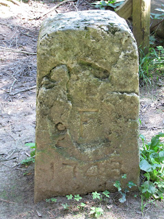
| Km 0 marker of the Western Front. Boarder marker No. 111 was chosen to symbolise the starting point of the Western Front at the Swiss boarder. The marker was installed in 1743 and bears the marks of the vicissitudes of history. From the Swiss side, the Berne Bear is a reminder that in 1815 the episcopal principality of Basel, which included the commune of Bonfol, was given to the Swiss canton of Berne. The year 1817 carved on the left flank recalls the year of verification of the line of the boarder by Swiss and French authorities. In 1793, the former principality, which had been proclaimed a Rauracian Republic the previous year, was annexed by France to become the departement of Mont Terrible. In 1800, this territory was incorporated into the departement of the Upper-Rhine and remained French until the fall of Napoleon Bonaparte. On the French side of the marker, you can see the various changes of nationality of Alsace through the successive traces of hammering of marks of sovereignty! |
 |
| Frontier marker 110 (left flank and front) |
 |
| Front of marker 110 |
 |
| Right flank of marker 111 |
 |
| Back of marker 111 |
In order to protect their neutrality and make sure that no party involved would jeopardize their boarders, Swiss constructed 6 checkpoints, 3 blockhouses in the Largue forests and at the Larghof-farm, as well as 2 observation towers.
 |
| Swiss Army observation post No. 2. Swiss Army observation post No. 2 is a wooden blockhouse faithfully rebuilt by Swiss Army engineers from 2012 to 2013. The Federal army occupied the Largin point throughout the Great War. The Swiss maintained the neutrality of their country thought careful surveillance of the boarder and by observing the actions and gestures of the two belligerants : the French on the left, the Germans on the right. The Swiss military installations were only made of soil and wood. They did not have a defensive function, being merely intended to protect the soldiers of the Confederation from stray bullets and the occasional intentional shot from one of the belligerants or the other.the defensive line was at Rangiers. The Porrentruy spur could not have been defended if invaded |
 |
| The entrance. The sign next to the entrance says "Das ist kein WC" ("This is a WC"). (I was surprised that there is a need for that kind of sign |
 |
| The inside of the post. It was quite spacious. It might have accommodated about 20 - 30 people. It's very possible that this post also served as residence, dining and sleeping area as well as chief post office |
The Swiss crew was divided into 3 groups: sentinels and
deputy, connection patrols, and dormant team. The daily activities included:
chopping wood, maintenance work, mushroom and berry picking and, of course,
playing cards. The service of a Swiss soldier was about 450 days (with a meagre pay).
 |
| Exit/entrance (depending on where you're standing) |
 |
| The way from the post. This path leads towards the current road to Largin farm |
 |
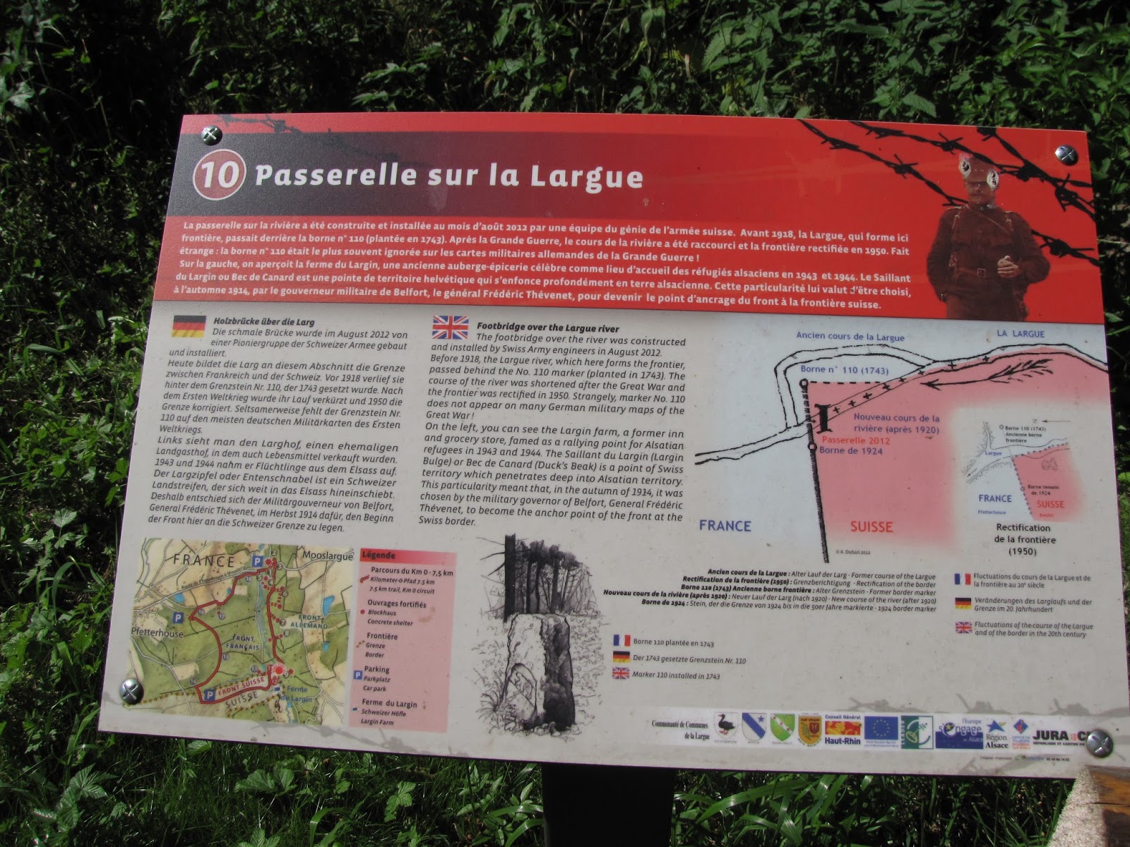
Footbridge over the Largue river. The footbridge over the river was constructed and installed by Swiss Army engineers in August 2012. Before 1918, the Largue river, which here forms the frontier, passed behind the No. 110 marker (planted in 1743). The course of the river was shortened after the Great War and the frontier was rectifier in 1950. Strangely, marker No. 110 does not appear on many German military maps of the Great War !
On the left, you can see the Largin farm, a former inn and grocery store, famed as a rallying point for Alsatian refugees in 1943 and 1944. The Saillant du Largin (Largin Bulge) or Bec de Canard (Duck's Beak) is a point of Swiss territory which penetrates deep into Alsatian territory. This particularity meant that, in the autumn of 1914, it was chosen by the military governor of Belfort, General Frederic Thevenet, to become the anchor point of the front at the Swiss border.
|
 |
| Footbridge. Switzerland |
 |
| On the footbridge facing Switzerland |
 |
| Largue riber. The natural barrier. Standing there I could not help but see soldiers walking from their blockhouses to get some water. The river didn't look the cleanest I have seen, but knowing the water shortages of the past, present and the future, the quality looses it's points on the priority list |
Just across the footbridge, there is the 110th frontier
marker mentioned in the description of the footbridge. It seemed to be in worse
shape than the previous ones.
 |
| Berne Bear |
 |
| "110" |
 |
| French lilly and an "F" with "1743" |
 |
| "1817" (side facing the river) |
We are in the 'German area'. Until 1915, German blockhouses
were also built from wood, but after this year, they were replaced by concrete
structures. Germans probably had the best position fortifications of all (they
haven't suffered any bad losses during the war after all).
There is a house(hold) that cannot be avoided while walking towards
the Zero point - the Largin farm. During (and before, if I remember correctly) the war, it accommodated a shop and a
restaurant. In 1916 on the
Christmas Eve, a bilingual Swiss soldier initiated a midnight supper between
Swiss, French and German soldiers here (and here you have another reason for
known more than one language). There used to be dances, parties organized in
the farm too. I don't remember when the shop and the restaurant was closed. The farm was one of the first stops for people, feeing to neutral Switzerland. Today the farm is still
operating and, if I remember correctly, belongs to the same family. It looks
almost the same as it originally did too. People I met there are very kind and
nice, and up for a good talk (you just need to be able to communicate in German
or French).
 |
| Largin farm as is seen from the footbridge |
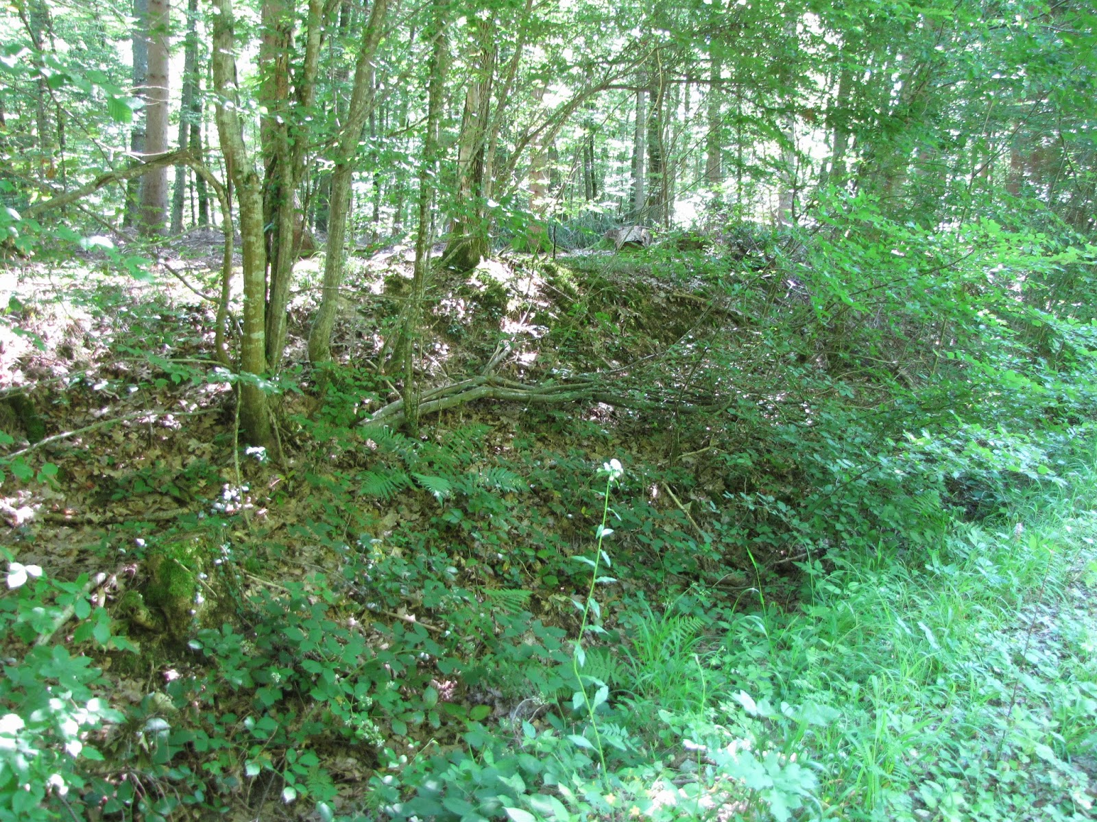
There were few long concaves around the bridge and towards
the German fortification. However, I am not sure about their origin.
Few steps further there is a description:
 |
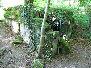
| First German position of the front. The German front started here and stretched to Ostend in Belgium, on the North Sea. This first defensive position is made up of three elements. The first thing one notices is the concrete blockhouses in the centre, designed to house a revolving canon. The large firing hole oriented towards the north, perpendicular to the frontline, indicates that the structure was intended to take on attack directed at the German lines on its flank. In front, a little to the east, a position directing fire from the pill box was supposed to be installed. Only the massive base, designed to hold a pentagonal steel sentry box covered the concrete, was ever built. Further back, there remain a sunken shelter in sheet steel for sentries. This defensive grouping is situated in line with the Swiss border |
 |
| Plan of the first German position |
 |
| I guess, that this is the concrete blockhouse that housed a revolving canon (or it might be the unfinished structure. but the large hole makes me think that it is the large firing hole) |
 |
| This is probably the base of the unfinished structure (its pentagonal inside). Or this is the blockhouse for revolving canon... |
 |
| Official plan from late 1916 for a machine gun pill box with ammunition store |
 |
| Probably the sunken shelter |
 |
| The sunken shelter (?). Camera case is used for scale |
In some pictures that were done 5 or 3 years earlier, I saw
the further structure in a better shape and without the "DANGER" sign
or the net.
 |
| I don't know to what part of the construction this structure belonged |
 |
| The same unknown structure. It might be a part of the sunken shelter |
 |
| The inside of the unidentified structure |
 |
| Start of the Western Front in 1916. Foreground - barbed wire on the German front ; background, left - North observation post of the Largin (Switzerland) ; background, centre and right - the French lines |
Even though the end (or, maybe, start) is considered as a
calm area, the traces of occasional artillery fire can be seen:
I walked all this area without my 'big brother' which I left
somewhere in the forest. I also forgot there my big candle. I came back to the
'big brother' to take the candle. I came back to the bridge and lit the
candle on it. It was
strange to sit and the footbridge. The water ran quietly under my feet. Not
surprisingly any more, it was hot, but the trees here gave some cover from the
blinding sun, whose rays were jumping here and there on the water surface,
with some of their energy penetrating right to the bottom. During these hot
hours even the birds where quiet. I remember thinking that from energetic point
of view, this is a total waste of artificial heat which, in addition,
contributes to the carbon dioxide emissions...
What a strange thought to have at a place like that...
I remember reading somewhere, that fire and water are the
two things that we can watch at for a prolonged time and loose ourselves. That's what happened to me. As I was sitting
there, I could see them both at the same time. My head went empty (I even forgot to take pictures!). I entered
something like a hypnotized trans state (or at least that's how I imagine it
might be). And then...
BUM!
BUM!
I saw shells exploding at both sides. Body parts flying together
with pieces of earth. The green colour that surrounded me vanished. The forest
was gone with only trunks and branches lying here and there together with bits
of pieces of flesh on the ground. It was
like looking at the sea in the middle of the ocean - nothing new no matter
where you turn. The only difference - it was ground, not water.
I don't know how long was I "zoned-out". After I
came back, I understood very well, that the images where not from here. They
were more appropriate for Saint Mihiel and everything up North-West from it. This
was the calm sector. The sector, where soldiers where relocated so they could
have some rest yet still fulfil their mandatory military service. A place, where "the
green ones" got their first smell of the trenches and blockhouses. But
even so, it still was a war zone...
Few hours later, I extinguished the flame with my fingers and walked towards my "big" and "little" brothers and the Largin farm.
Part II: People
(sadly, I don't remember all the names of the people I met
at Largin...)
When I walked towards the frontier, I saw a group of
friends having a nice pick-nick, I felt a bit intrusive. We exchanged
greetings, and I already planned to quickly be done here and be gone.
As I was standing in front of one of the descriptions, I head a man behind me. He
was speaking in French so I thought that it's not for me. But as it turned out,
they were inviting me to join them. I was thirsty as if I had been walking the
desert so water was the most precious thing. I joined them and we had some nice time discussing politics, history,
social and cultural issues, civilization evolution and collapse. One lady was
learning Russian for some time, so we had some exchanges in this language too. All of them
had owned a restaurant or worked with restaurants in one way or another. I spend
few hours with them and the time seemed to fly by. One of them was interested
in history so he had an album with cards and pictures from the First World War. German,
Swiss and French soldiers standing next to each other. Side by side. Shoulder to
shoulder. If one didn't know the circumstances, it would be very easy to
mistake them for comrades....
After they drove home, I explored the front. Later I
walked to Largin farm to ask for some water. I ended up getting mineral water (from a
bottle) and a nice discussion about history and behaviour leading to wars. Amazing.
Later, I took my way back to Pfetterhouse. I decided to
hitch-hike to Saint-Mihiel as I thought that starting to walk from there, I
would have a chance to finish everything in the 20 days I set up for myself (and told my family)...)
 |
| Boarder Switzerland-France |
Part III: Pfetterhouse
Little history:
Pfetterhouse is an old village (first mentions of village
Petrosa are dating year 731 - 732). It is certainly known that the village existed
already in Roman times with Germans later ading -husen (-hausen) suffix
resulting "Petrosa" to become "Pfetterhausen".
 |
| The church. Built in 1884 - 1888. The tower was finished in 1900 |
The village had two churches. One of the churches, dedicated
to martyrs St. Dizier and St. Andoche (I have no idea if that's their names in
English too), was standing in a place of a house (now rue de la Montagne 2). Later
the church was sold and the ownership transferred from one hands to the others until it became a chapel of St. Nicolas. Eventually, after the Revolution, the
building was sold and transformed into a farm.
Another church was located near the current elementary
school. It might have been built in the Middle Ages. In the 19th century the
church became too small and the town decided to built the new church located in
the city center.
After the Treaty of Frankfurt (year 1871, after the Franco-Prussian
war), Pfetterhouse became a border village, a meeting point of France,
Switzerland and Germany. The marking stones were set up in 1890 (I haven't seen
them). Inns, stores, postcards and smuggling were thriving here during that time.
But Pfetterhouse was not only a village of smuggling
goods and inns. It was here that Louis Pasteur, the father microbiology, used his
vaccine against rabies on little Joseph Meister.
Another interesting thing, that because of its location and
lower costs in the German Empire, Pfetterhouse was very popular village for
Swiss watchmakers. First, only the assembly of watches were located in
Pfetterhouse, but gradually they started to make their own parts and ended up
producing up to 300 000 watches that were sold all around the German Empire. This
industrial development led to the building of the railway that eventually
turned out to be the famous international rail-line Pfetterhouse-Bonfol.
When war broke out, French army entered the village in 7th
of August. Swiss watchmakers fled to back to their country. The French pushed
the Germans towards Largue where the front line would eventually stabilized.
French settlers later came to the village and schools were re-opened. However,
the lessons where held in French now.
The village stayed in French hands right until Nazi took it
in 1940. The German language returned. After the second war, the village returned to
the French once again (Alsace-Lorraine ping-pong).
Right next to the church, a monument to the fallen for
France is erected.
 |
| On one side of the monument are the names of the fallen from the First World War on the other - from the Second World War |
This small village is full of interesting and beautiful
country architecture (this subjective opinion might be influenced by the difference
of Lithuanian and French village architectures).
 |
| I wonder if the car was matched to the house purposely..? |
Despite the small size of the village, there is a motorcycle club here
 |
| Bicycle and foot path. I have no idea what is the construction. Maybe it had something to do with the railway..? |
That's it. The day is done. I went back to the same fish pond (as it was too late to hitch-hike and walking to some other location didn't seem worth it).
Goodnight.
 |
| Sunsets there are beautiful |


Comments
Post a Comment